
Have you ever wanted to refer to the SimplePlanes world map when playing?
If to search, there will be some pictures of islands, and even schematic views of SimplePlanes world, but what if there would be the online interactive map where you can navigate all across the world, track coordinates or even add some marks?
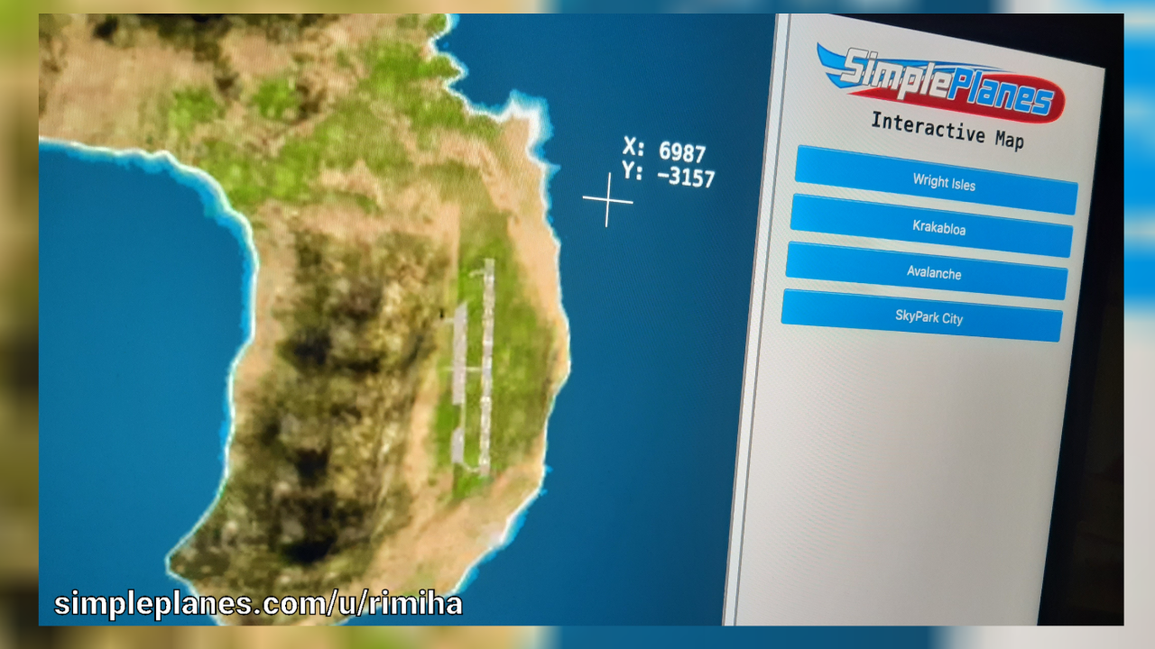
A few days ago i questioned this and today here is a simple prototype that allows navigation across main islands, free scale of the view and tracking the coordinates of a pointer. You can see how it looks in the top of the post.
Now i would like to know the community's opinion on this topic:
1. Have you ever encountered the need (or just the desire) to use such map?
2. Are there working implementations of SimplePlanes map that would allow interaction you know?
3. What could be the use cases of such map?
4. What features could make the map more useful?
5. At the moment map only displays X and Y coordinates (Latitude and Longitude). Do you think adding Z coordinate (Ground level) would be useful?
Any questions, ideas or suggestions are welcome
If you want to participate or help:
At the moment the biggest lack is high-quality and accurate images of the islands. The available images on the internet are usually out of date and have low resolution. Ideally it should be a 2-4k image of each island separately in orthographic view, since a perspective view creates distortion, and as a result, inaccuracy in displaying on the map.
If you know how to make high quality images in the orthographic view or even can make some and post them to image hosting, welcome to a comments! I will gladly mention participants.
Map is already available. More information, link and further updates will be at this post: https://www.simpleplanes.com/Forums/View/2049353/RELEASE-SimplePlanes-Map
added this to SimpleCheats II
@32 No problem, thanks for letting me know👍
@rimiha to be honest I haven't turned my PC on in about a week, I'll try and get to it but I do have stuff going on irl so I don't know when I'll get to it. If you have a windows computer that's 5 years old or less you can probably run the correct Unity version yourself, and mess with it, I know waiting for other people to help with projects sucks sometimes. If you don't hear back from me for a week or so feel free to remind me, I'll do my best.
@32 Hello, how things are going? Have you tried to access islands in Unity? Any update would be appreciated
@rimiha I'll try and access the islands, I know the meshes are in the mod tools but I'm not sure if there's texture. I'll do my best and see what I can come up with. I do know how to grab the depthmap and there's actually a google drive link to the wright island one, so here's the link to that while I try to get those screenshots. https://drive.google.com/file/d/1NJLSKYuSfY9hZa9bLnYtyzuqBQgeirgl/view?usp=share_link
@32 Hi, thanks for the comment!
Yeah, it would be really great to get isometric view of the islands from Unity. I don't know how the SimplePlanes project is built, but if you can get access to the default islands terrains, you can do the following:
Create a camera, point it north and rotate it down.
Switch camera mode to the Orthographic ("Projection" setting at Inspector).
To get really high resolution images of the islands, one screenshot of the whole island may not be enough, and it's better to take several pictures with smaller scale to then combine them into one large high-resolution image of the island.
I think it would be most efficient to enter the full screen mode having scene editor and game mode splitted, so one window is used to move the camera across the terrain, and another window is used to take a screenshots.
As for getting the height data, seems like Unity allows you to directly export the height map without any tricks.
All above is just my vision of how it can be done and of course you can do it as you see fit.
Hope you find following resources useful:
- How to setup Unity camera
- How to export height map from Unity
z axis would be useful for some applications, if you could get a depthmap of the different islands you could pretty easily translate that into coordinates on the z level. I think Unity might be the place to get screenshots of the map, although finding a way to set the view distance very high then set the FOV to be pretty narrow might work.
If you need someone to mess around in Unity I would for sure be willing to try, but my skills are very limited and it might work better to get something to hand draw everything to scale with the depthmap image or something like that.
@rimiha
Yes, 3d would probably be pretty hard though.
I need this!
@TheMouse Hi, thanks for the comment!
[3] I not sure about the integration into the game. This map is being developed as a static website, which has very little to do with in-game stuff. I think being a website, the map will be more accessible to the community, regardless of their platform. Although the idea of an interactive map in a plane sounds pretty cool! Especially if the map is integrated with FunkyTrees.
[4] The zoom feature is already implemented - you can change the map scale from x0.01, when you can fit all the islands in the viewport, to x5 to see small details (as far as the resolution allows, haha). Airport and other object markers are already in development, along with the ability to hide layers with checkbox. But when you talk about google maps and different perspectives, you probably mean making this map 3D?
Will be keeping a close eye on this